|
|
Post by Malcore on May 6, 2007 22:13:31 GMT -9
Well I went to Moose Creek and tromped around in the woods for a few hours trying to find a few that were suposed to be there, but two of them are now in the middle of the Matanuska river and one is in an area of Moose creek that gets flooded a lot so looks like it's gone. So no finds there. But I did find part of the railroad trail and walked along it for a while and found a interesting Cadastral benchmark. Heres a pic: 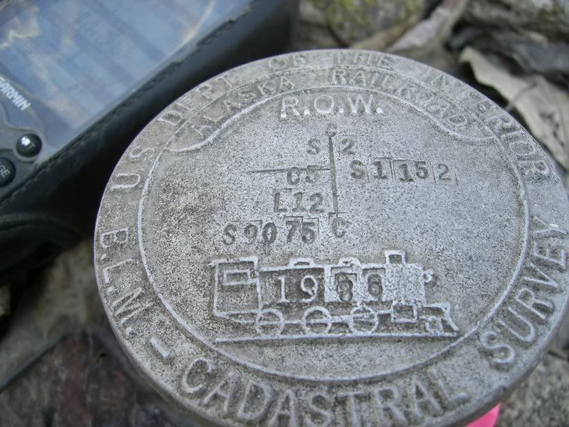 I did find a mark on the bridge at about the right location but there are no identifying marks on it. Is it posable this is a replacement one for the origonal one and they just didn't mark it? Or is it possable theres another one somewhere else on the bridge? Heres a pic: 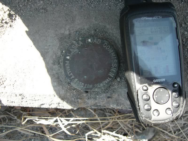 Then I went down the road a bit and this is where I got totaly confused. I started looking for TT0637 and noticed that the posted coords for TT0636 are exactly the same, the only difference is one is stamped MOOSE RM1 and the other is MOOSE RM2. Is that normal? I didn't find ether one of those at or near the coords. But what I did find was this:  and 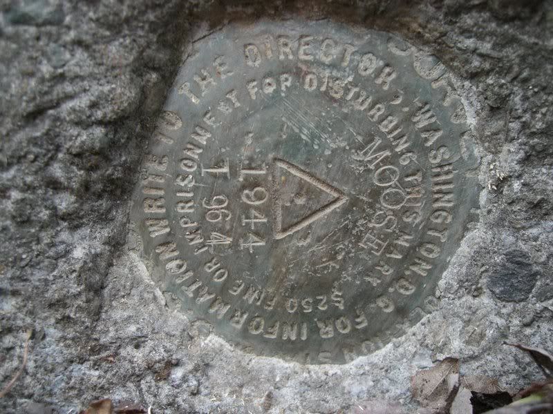 It was about 50' from where the others are supposed to be. From what I have read that one should be on the other side of the highway, so you can see my confusion. what I have to figure out is how I need to log what I found. Its tough to go into detail in a message so if more info is needed I would be glad to get togather with anyone to go over it all. The day was fun even with the problems and im defenently going to do this more. |
|
|
|
Post by ladybugkids on May 7, 2007 6:19:24 GMT -9
Cool railroad/BLM cadastral survey mark. It won't be in the NGS database, but that's a fun one to see. I can't tell you anything about the Alaska Road Commission disk on the roadroad bridge. What I can tell you is that NGS disks on railroad bridges can look like this find of TT2772 I recently made in Fairbanks: 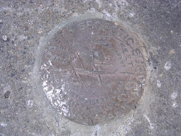 Looks like you found MOOSE RESET, UW8102, which was apparently reset in 1964 after originally being set in 1944. "THE STATION MARK IS A STANDARD DISK STAMPED MOOSE 1944 1964, SET IN THE TOP OF A CYLINDRICAL CONCRETE POST 12 INCHES IN DIAMETER AND PROJECTING 4 INCHES ABOVE THE GROUND." However, it looks like it got "reset" again by heavy equipment given its current orientation. Moose RM1 and RM2 have scaled coordinates, which mean they were established by someone reading them off a map. In some cases they can be several hundred yards off. Both marks were logged as "not found" by NGS in 1964, so they might be gone or plowed under by Glenn Highway reconstruction/realignment. That said, the 1985 log for UW8102 says RM 2 and 3 were recovered, yet there is no recovery note for RM2 and RM3 doesn't appear in the "nearby" marks search. I'm certain NorthWes can chime in with a better/more expansive explanation. BTW...benchmark finds not in the Benchmark database may also be logged in the gc.com US benchmarks waymarking category. |
|
|
|
Post by NorthWes on May 7, 2007 15:26:17 GMT -9
Congratulations, Malcore! An AWESOME find!
You've earned the right to report UW8102 MOOSE RESET both on geocaching.com and to the National Geodetic Survey as recovered but definitively destroyed! Based on the photos you provided, what you found is the benchmark and its 'setting' (the concrete plug), lying out on the ground, obviously removed from its original placement (as described on the 'original datasheet'). I'll try to sit down tonight and send you details on how to log this recovery. It would make a good thread in this part of the forum, eh?
Nearby MOOSE RM1 and MOOSE RM2 are reference marks, with arrows pointing towards MOOSE stamped into their cap. It makes sense that they would have the same coordinates as MOOSE, as they were 'scaled' locations (the lat/long taken from a topo map rather than from a direct observation on site) only 30 feet or so separated from the main mark at MOOSE RESET. They would be logged on geocaching.com as 'DNF' and then annotated in your log as 'presumed destroyed by roadwork', with an explanation why you drew that conclusion. As you didn't actually see the destroyed reference marks, you can't log ithem as 'Destroyed' with the NGS - only 'not found - presumed destroyed'.
As for the AK Road Commission marker, the mystery deepens. That mark is not TT0640 Q 87 1964 (the loggable mark is set on the southeast end of the northeast bridge seat, stamped Q 87 1964). The mark in question (TT0640 Q 87 1964) was set in 1964, which is eight years after the AK Road Commission was absorbed into the federal Bureau of Public Roads. Thus, the mark you photographed on the bridge structure predates TT0640! I found no other markers in the vicinity described as being stamped with Alaska Road Commission. Were there any faint marks on the disk which may have been the Q 87 stampings? Perhaps you weren't on the SE end of the NE bridge seat? In any case, it's a historic item, probably dating to the original construction of a paved road there.
The BLM Cadastral Survey Mark is intriguing - why is there a RECENT (1986) Alaska Railroad land ownership survey marker so far from the mainline of the Alaska Railroad? Another mystery...
This is a classic example of why benchmark hunting is so fun. Historical mysteries, location mysteries, and terrain mysteries due to changes since the original description was provided - FUN STUFF!
|
|
|
|
Post by Malcore on May 7, 2007 18:09:34 GMT -9
Actualy I did find Moose RM2 on the other side of the highway. at the time I was looking for UW8102 which should have been Moose 1944 1964. heres the pic: 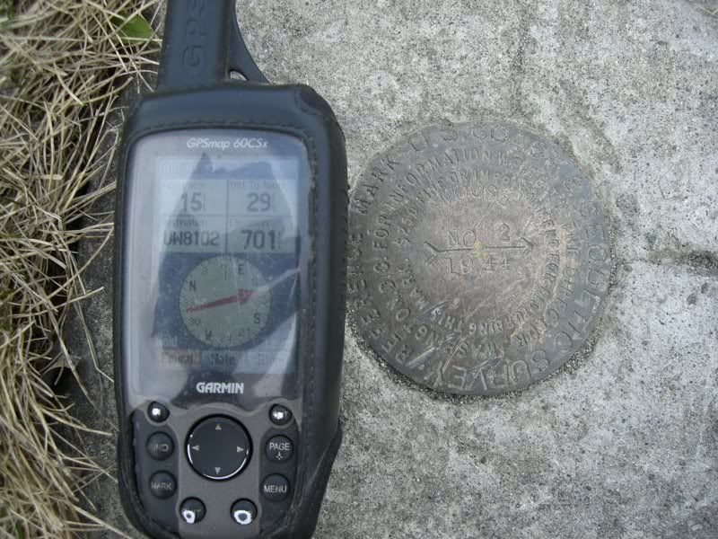 More of me being confused. The gps shows that UW8102 is 29' in the direction of the arrow but that would have put it in the highway. This one is actualy in someones yard and so first thing I did was ask the owner if she minded if i could look for it. She said it was ok and even showed me where it was. She did say that other people have come to use that benchmark for taking readings and such, even survayers from fairbanks. I did find out that the highway there is going to get road work done very soon and there planning on cutting the highyaw down 90' right in front of her house and it will probibly distroy all the benchmarks in the area. Also that if it makes it impossable to get to her house from the road they may even have to take her house and even a new house across the highway. That would be a shame. It looks like there trying to make the highway in that area have less of a grade. Which it's needed for a long time. |
|
|
|
Post by oleruns on May 7, 2007 20:40:20 GMT -9
Good Job on the benchmarks Malcore! I am learning from your questions - I could not help but notice the buttons on your GPS are well worn. I wish I could have one long enough to see that happen.  I think I have another button pad you can have ;D
|
|
|
|
Post by NorthWes on May 8, 2007 8:14:31 GMT -9
Double wow on finding Moose 2! OK - now I really need to get with you. I'd like to find those myself before the new construction tears it out. I'll be emailing...
|
|
|
|
Post by Malcore on May 8, 2007 20:46:16 GMT -9
I would be glad to go back and find these again and maybe even find the other refrence marks.
I see now that a tape measure is a good thing to have. I didn't have one so couldn't get any real accurate measurments. Also I didn't use the metel detector to search the area so if any marks were just under the surfice I wouldn't have found them.
|
|


 - - - - - - - - -