|
|
Post by Malcore on May 17, 2007 16:13:07 GMT -9
Can anyone tell me if this is the benchmark for TT0692 : 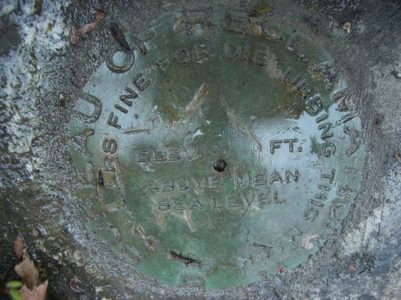 I was up by Eklutna with Oaf3 getting one of the caches there and thought we could look for a few benchmarks in the area. This is what we found 97 ft from the TT0692 coords, could this be the correct benchmark? Or do you think it's just another mark that isn't in the database? I don't know enough about the different types of benchmarks to tell what type this is. It says 'BUREAU OF RECLAMATION' around the outside. I don't want to log this as a find unless I can figure out if it's the correct mark. |
|
|
|
Post by Forum Admin on May 17, 2007 16:28:21 GMT -9
The USGS couldn't find TT0692 in 1977. The data sheet doesn't give enough descriptive information to indicate it was labeled anything other than a NGS benchmark. I'm not the expert but I would say this is not the subject benchmark.  |
|
|
|
Post by Malcore on May 18, 2007 21:34:21 GMT -9
Thats what I thought also. These things are so random in there location it's hard to figure out whats what.
We found 4 benchmarks that day and it looks like none of them are in the data base. Oh well, atleast im looking for them more.
Thanks for the help
|
|
|
|
Post by NorthWes on Aug 7, 2007 11:20:29 GMT -9
I was looking at the thread about Moose Creek (after a caching run up near there last Saturday with Scobey) and realized I'd never looked at this thread about Eklutna road recoveries in detail.
I actually believe you've found TT0692, Malcore. Being off by 97' is no big deal on a scaled mark; happens to me on better-marked recoveries all the time. My evidence for saying this is TT0692 is based on this excerpt from the original NGS Data Sheet:
TT0692 HISTORY - Date Condition Recov. By
TT0692 HISTORY - UNK MONUMENTED BOR
TT0692 HISTORY - 1965 GOOD NGS
TT0692 HISTORY - 1977 MARK NOT FOUND USGS
The first line of actual data is the 'monumented' history - meaning, the information about when it was installed by whom - in this case, the date of the monument being placed is UNKnown, the condition is MONUMENTED (meaning the actual installation of the monument), and the Recov. By is BOR (meaning the Bureau of Reclamation - the 'monumentor' or installer - which is the federal agency overseeing things such as dams and hydroelectric plants - like the Eklutna project!). The next agency to log a recovery (find) of the mark is the National Geodetic Survey in 1965, and in 1977 the US Geological Survey wasn't as adept at finding the mark as Malcore was in May 2007.
So, log that puppy on geocaching.com (with coordinates to update its location) and turn in a recovery report as 'found' to the NGS (with a note in the bottom section - HANDHELD GPS COORDS N6XXX W14XXX etc! See the other thread in this section on how to do that... or email me. Cool find!
|
|
|
|
Post by Malcore on Aug 8, 2007 17:22:00 GMT -9
Cool. The way you explain it makes sence. I guess you realy need to know what all the abbreviations stand for to know what your looking at.
Unfortunatly I deleted the coords I had marked from my gps so I will have to take another trip out there and get them again. Although it will give me a chance to get the other caches in the area that I hadn't got yet. Thanks NorthWes
|
|
|
|
Post by NorthWes on Aug 8, 2007 17:38:22 GMT -9
Unfortunatly I deleted the coords I had marked from my gps so I will have to take another trip out there and get them again. Say it isn't so... I guess I'm the packrat of waypoint files. I download and save all my travels... I have hundreds of tracks & countless waypoints saved... What a database mgmt issue when I'm trying to refind a particular waypoint... but it pays off sometimes! |
|
|
|
Post by Malcore on Aug 8, 2007 17:51:28 GMT -9
Haha your probibly right, I should have kept then on the computer. Im not good at managing all that. Luckly the benchmark is right next to the road and will be easy to find again.
|
|